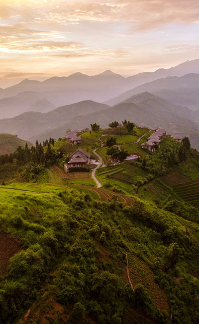
VIETNAM – Pu Luong – Mountains and Villages Trekking 3D2N
Pu Luong is not just famous for its incredibly beautiful rice field terraces. From the river banks to the towering mountain, the villages to the small trails, and both Thai and Muong minorities, all of Vietnam’s diversity seems to be gathered here in this amazing nature reserve.
Theme
Art & Culture, Classic, Sustainable
Country - City
Vietnam - Pu Luong
Level of difficulties
LEVEL 3
Price level
$$$$
Seasonality
All year round - rainy season June - September
Max number of person(s)
15
Market segment
Arrival City
Pu Luong
Departure city
Mai Chau
Number day and night
3 days - 2 nights
Day by day description
This 3-day, 2-night itinerary is designed for active travelers who are eager to put on their hiking shoes to explore Pu Luong and its valleys brimming with forests, rice paddies and rice terraces. The trails of the valley lead hikers through the villages of Thai minority tribes and give them the opportunity for close contact with the inhabitants, as they stop to sleep in village homestays.
Selling points
- To discover Pu Luong National Reserve by going through many villages, rice terraces and forest
- To interact with local people from the Thai, Muong minority group and understand their local life by visiting the villages and staying at the homestays
- An active routine for a hiker experienced in everyday hiking.
Level Of The Excursion
Medium – This activity offers tangible positive contributions to the local community, culture and/or environment
The Impact Of This Excursion
Social/cultural Impact
Involving minorities
Environment Impact
Transportation
Economic Impact
Community benefits
Additional Information
Positive Impact:
Extensions
- Mai Chau – Hiking in the enchanted Mai Chau landscape
- Ninh Binh – Lunch in a Local House
Selling points
- It’s suitable for a long day active request
- Easy to combine with Mai Chau or Ninh Binh to make a multi-day program
- Suitable for FIT or small group in good health and fit
- Many different environments from village to village, from rice field terraces to the jungle/forest
- All of the homestays are nice and clean with very good, local food
Pros
- Easy to access from Mai Chau
- Beautiful landscape with impressive rice fields in some parts (Ban Hang to Eo Ken, in the valley around Kho Muong and in the area around Ban Uoi)
- Homestay hosts understand the services and have experience from doing marathon campaigns here
- Local guides perfectly know the region
Cons
- No access for the bus or van in the valley (parking place near the main road )
- Travelers have to walk and the paved main road sometimes (the longest is 7 kilometers)
- Can be a lot of insects at the homestay (depending on the season and the location of the homestay)
- National Guide Easia Travel must train guides for the hiking tours
- Only Vietnamese-speaking local guide
- No backup plan is available for some parts (even motorbikes would not pass)
- Some parts can be very slippery on a rainy day
- No Wifi in Kho Muong
- The homestays have a limited number of showers (1-3 depending on the homestays)
TIME AND TRANSPORTATION
| From | To | Kilometers | By | Duration | Road conditions |
| Mai Chau | Pu Luong | 50 kilometers | Bus | 2 hours | Good |
| Pu Luong | Ninh Binh | 130 kilometers | Bus | 4 hours | Good |
Notes
- MAP: https://drive.google.com/open?id=1Uti2uZES1whYVxS-oO_t6-tevApjwJFI&usp=sharing
- This trek should not be organized from Pu Luong, since the trek passes through the main road from Mai Chau to Pu Luong (it would be strange for guests to go by car only to come back walking).
- The trek is not like in Sapa where you have rice terraces all the time; this trek is a mix between rice fields, rice terraces, other kind of fields and nature.
Sensitive Activity – Notes for the Sales
This experience implies a lot of money spent directly in the countryside of Pu Luong, on itinerary not a lot of travelers go to.
it will help several local people to have jobs and earn money (local guide & homestay owners)
Market suggestion
AUSTRALIA
BENELUX
CANADA
CEE
GERMANY
ITALY
SPAIN
SCANDINAVIA
US
FRANCE
UK
BEST FOR FIT
PORTUGAL
Important notes
Services to be booked:
- Local guide: 1st choice: Mr. Thiep
- Lunch for the client, luggage transfer (if needed), Meeting with local old man, bamboo drafting (when available): book through local guide Mr. Thiep
- Need to recheck with Easia guide and local guide for every bookings, make sure that they know/understand the program.
- Need to book with local guide, local homestays at least 2 weeks in advance
- Starting point: Gas station Phu Le – QL 15
- Check with local guide the condition of the routine
- During rainy season, language guide should verify the trails with the local before the hike
- Local Guide + the language guide should have a first aid kit
- Train the local guide to wear “active clothes” (no nice skirt and pants) = > jean + T shirt + shoes
- SERVICES Snack package (Twice per day): includes water (3L pax/day) & snacks for ACTIVE Guest only
Should be bought in advance from Hanoi or booked with the Homestay(fruits- local cereals) as there is no ” shops” near the homestays - Train the homestay to not use Plastic if possible
- NATIONAL GUIDE
- Always remember to provide the first aid kit to the Guide
- Explain clearly to the Guide the profile of the Client and expectation of the Travelers
- Guide must be flexible on the spot and the guide must adapt the speed and the length of the trails to the needs of the travelers
- Have to study the tour with operation – Map
- Should check the cold water & snacks every day (number and place to buy and when)
- Should have lunch together with the Active travelers
- Should check the climate conditions before the tour to avoid risks (for example; bring raincoats) and be careful during the tour not to put the lives of the guests in danger.
- Language – use polite language and adapt the behavior depending on the guests’ character and behavior
- Shoes – proper shoes – please no sandals or flip flops
- Uniform – guide must dress properly, using hiking clothes
Sensitive Activity – Notes for the guide:
Guide should explain to the travelers how important getting job is for local people for minorities (which are generally poorer than ethnic Kinh), particularly in Pu Luong where it helps young generation to stay in the region.
It’s important to mention that sleeping in homestays will benefit local inhabitants
Guide should remind the travelers about how to act politely with minorities (in case the travelers want to take a picture for example)
Contact
- Hieu Yen Homestay – Ban Hang – 038 204 5782
- Lo Van Nam Homestay – Kho Muong – 0944325132
- Local Guide Mr. Thiep – 033 6116 609 or Mr. Thuc (Mr.Thiep’s brother) – 0973 779 588
- Local Guide Mr. Huong – 097 660 5956 (from Pu Luong Retreat and Pu Luong Rice house)


English
Day XX: Mai Chau – Pu Luong
After lunch and a departure from Mai Chau to the north of Pu Luong Nature Reserve, you will trek from the main road, which meanders along the river bank, via a path that connects two parallel ranges of mountains in the reserve. The first part is mostly uphill, with amazing views of the rice fields and some local villages, before you reach the paved main road in the other side. Then, a quick down hill road toward the Hang Village leads you right to the night’s accommodations.
Accommodation: Homestay in Hang Village
Meal: Dinner
Level 1
Distance and duration of the walk: 10 kilometers – 3 hours
Terrain – ascent and descent which could be slippery in case of rain
Total Gain elevation : +60 meters , ( +203 / -143 meters)
Transportation: Mai Chau – Pu Luong – 21 kilometers – 50 minutes/1 hours
Note: The hike requires to be equipped with good walking shoes, long pants and sun protection.
Day XX: Pu Luong
Early in the morning, guests will start the trek from the valley towards the southeast, following villagers’ trails to venture through the forest and finally reach the other side of the stream via a special bridge, crafted by a local. Then, prepare yourself for an uphill trekking challenge, before taking a break at a local house and chatting with the immensely friendly family about their local lives.
After your visit, spend some time making your way on the paved main road, and lunch in a local house will be waiting along the way on the road. After a delicious and well-deserved lunch, you will make your way to the the welcome gate of Dong Dieng Village and begin your trek once more. Traversing the rolling hills along the hidden trails through the forest of beautiful, diverse flora, you’ll finally reach the bottom of the valley, where you’re completely enveloped by the lush rice fields of Kho Muong Village. Finish off your day with a walk around the village to discover its hidden charm and then cozy up for your overnight stay.
Accommodation: Homestay in Kho Muong Village
Meal: Lunch, Dinner
Level: 3
Distance and walking time: 17 kilometers – 7 hours
Terrain – ascent and descent with small trails, hidden paths, paved main road. Some paths could be slippery because of the rain
Total Gain elevation : +196 meters ( +743 / -547 meters)
Note: The hike requires to be equipped with good walking shoes, long pants and sun protection.
Day XX: Pu Luong –
Early in the morning, you will continue along the trails from Kho Muong Village toward Uoi and Don Village. The trails will lead through some mandarin gardens, as well as bamboo and tree forests, where you can catch a fantastic glimpse of the villages and their rice field terraces from above. Then, simply follow a stepped dirt road to reach to Don Village. You will finish your day of trekking by noon, and then you’ll be off to your next destination.
Accommodation:
Meal:
Level: 2
Distance and walking time: 10.2 kilometers – 4 hours 30 minutes
Terrain – ascent and descent with small trails, hidden paths, rock stairs, some path could be slippery because of the rain
Total Gain elevation : +45 meters ( +383 / -338 meters)
Note: The hike requires to be equipped with good walking shoes, long pants and sun protection
French
Randonnée dans les Montagnes et Villages 3J2N
Jour XX: Mai Chau – Pu Luong
Après le déjeuner, vous quitterez Mai Chau en direction du nord de la Réserve naturelle de Pu Luong. Vous commencerez votre randonnée à partir de la route principale qui serpente le long de la rivière par un chemin qui connecte deux chaînes de montagnes parallèles. Pendant la première partie de la marche, sur des chemins principalement en montée, vous pourrez admirer de superbes rizières et des villages locaux avant d’atteindre la grande route pavée de l’autre côté. Vous emprunterez alors une route descendant vers le village Hang et rejoindrez le lieu où vous passerez la nuit.
Hébergement : chez l’habitant au Village Hang
Repas : Dîner
Niveau 1
Distance et durée de la randonnée : 10 kilomètres – 3 heures
Type de terrain – en montée et descente, sol susceptible d’être glissant en cas de pluie
Dénivelé Total : +60 mètres , ( +203 / -143 mètres)
Transport : Mai Chau – Pu Luong – 21 kilomètres – 50 minutes/1 heure
Remarque : pour la randonnée, il vous faudra de bonnes chaussures de marche, des pantalons et de la protection solaire.
Jour XX: Pu Luong
En début de matinée, les voyageurs commenceront leur randonnée depuis la vallée en direction du sud-est en suivant les chemins de villages et en s’aventurant dans la forêt jusqu’à atteindre l’autre côté de la rivière après avoir emprunté un pont particulier, fabriqué par les habitants. Il faudra ensuite se préparer à l’ascension après laquelle vous pourrez vous reposer dans une maison locale et discuter chaleureusement avec la famille à propos de leur mode de vie.
Après votre visite, vous prendrez le temps de rejoindre la grande route pavée et vous déjeunerez dans une maison locale sur le chemin. Après ce délicieux repas bien mérité, vous vous rendrez à l’entrée du village de Dong Dien où vous reprendrez votre randonnée. Vous traverserez les collines sur des sentiers cachés dans la forêt et admirerez la flore aussi diverse que magnifique, avant de finalement arriver au fond de la vallée où vous serez complètement enveloppé par les rizières luxuriantes du village de Kho Muong. Vous finirez la journée par une promenade dans ce village au charme discret avant de rejoindre votre logement pour la nuit.
Hébergement : chez l’habitant au Village Kho Muong
Repas : déjeuner, dîner
Niveau : 3
Distance et durée de la randonnée : 17 kilomètres - 7 heures
Type de terrain – en montée et descente avec de petits chemins, des sentiers cachés, la route principale est pavée. Certains chemins pourront être glissants en cas de pluie.
Dénivelé Total : +196 mètres (+743 / -547 mètres)
Remarque : pour la randonnée, il vous faudra de bonnes chaussures de marche, des pantalons et de la protection solaire.
Jour XX: Pu Luong –
Vous reprendrez la route de bon matin et suivrez les chemins partant du village de Kho Muong vers les villages d’Uoi et Don. Les sentiers vous mèneront à travers des jardins d’agrumes et des forêts de bambous et d’arbres et vous pourrez apercevoir les villages et leurs rizières en terrasses depuis les hauteurs. Vous suivrez ensuite une route de terre pour rejoindre le village de Don. Votre journée de randonnée se terminera aux alentours de midi et vous pourrez ainsi continuer votre route vers votre prochaine destination.
Hébergement :
Repas :
Niveau : 2
Distance et temps de marche: 10,2 kilomètres - 4 heures 30 minutes
Type de terrain – en montée et descente avec de petits chemins, des sentiers cachés, des escaliers en pierre. Certains chemins pourront être glissants en cas de pluie.
Dénivelé Total : +45 mètres (+383 / -338 mètres)
Remarque : pour la randonnée, il vous faudra de bonnes chaussures de marche, des pantalons et de la protection solaire.
Spanish
Trekking entre montañas y pueblos (3 días y 2 noches)
Día XX: Mai Chau – Pu Luong
Después de almorzar y salir de Mai Chau hacia el norte de la Reserva Natural de Pu Luong, realizará una excursión por la carretera principal, que discurre a lo largo de los márgenes del río a través de un camino que conecta las dos cordilleras montañosas que se asientan paralelamente en la reserva. La primera parte será principalmente en ascenso, ofreciendo unas vistas impresionantes sobre los campos de arroz y algunos pueblos locales, antes de llegar a la carretera asfaltada al otro lado. Más tarde, una carretera que desciende hasta el pueblo de Hang le llevará directamente hasta su alojamiento de la noche.
Alojamiento: estancia nocturna en el pueblo de Hang.
Comidas: Cena.
Nivel 1.
Distancia y duración de la excursión: 10 kilómetros – 3 horas.
Terreno – ascendente y descendente, con tramos que pueden resultar resbaladizos en caso de lluvia.
Elevación total del terreno: +60 metros, ( +203 / -143 metros).
Transporte: Mai Chau – Pu Luong – 21 kilómetros – 50 minutos /1 hora.
Alojamiento: estancia nocturna en el pueblo de Hang.
Nota: para esta excursión necesitará ir equipado con calzado adecuado para caminar, pantalones largos y protección solar.
Día XX: Pu Luong
Temprano por la mañana, los visitantes comenzarán la excursión desde el valle hasta la región sureste, siguiendo los caminos marcados por los habitantes de los pueblos para aventurarse a través de un bosque y finalmente llegar al otro lado de la corriente a través de un puente especial construido por los locales. Posteriormente, prepárese para un tramo ascendente que supondrá todo un desafío de trekking. Más adelante, hará una pausa en una casa local y charlará con la agradable familia sobre la vida local.
Después de su visita, pasará un rato encontrando el camino por la carretera principal hasta llegar a una casa local donde le estará esperando el almuerzo. Después de disfrutar de la deliciosa y bien merecida comida, se dirigirá hasta la entrada de bienvenida del pueblo de Dong Dieng y comenzará de nuevo su excursión. Serpenteando a través de las montañas onduladas y los caminos escondidos del bosque entre bella y diversa flora, encontrará finalmente el final del valle, donde se verá completamente rodeado de los exuberantes campos de arroz del pueblo Kho Muong. Finalizará su día con un paseo por el pueblo para descubrir su encanto escondido y, más tarde, se retirará cómodamente a dormir en su alojamiento de la noche.
Alojamiento: estancia nocturna en el pueblo de Kho Muong.
Comidas: Almuerzo, Cena.
Nivel 3
Distancia y duración de la excursión: 17 kilómetros – 7 horas.
Terreno: ascendente y descendente, con pequeños senderos, caminos escondidos y una carretera principal asfaltada. Algunos tramos pueden resultar resbaladizos por la lluvia.
Elevación total del terreno: +196 metros, ( +743 / -547 metros).
Nota: para esta excursión necesitará ir equipado con calzado adecuado para caminar, pantalones largos y protección solar.
Día XX: Pu Luong –
Temprano por la mañana, continuará por los caminos del pueblo de Kho Muong en dirección a los pueblos de Uoi y Don. Los senderos le llevarán a través de jardines mandarines, así como bosques de bambú, donde podrá observar el fantástico paraje que conforman los pueblos y las terrazas de los campos de arroz desde lo alto. Posteriormente, simplemente tendrá que seguir una carretera de tierra para llegar al pueblo de Don. Finalizará su día de excursiones a mediodía y, posteriormente, se dirigirá a su próximo destino.
Alojamiento:
Comidas:
Nivel
Distancia y duración de la excursión: 10.2 kilómetros – 4 horas y 30 minutos
Terreno: ascendente y descendente, con pequeños senderos, caminos escondidos y escaleras de roca. Algunos tramos pueden estar resbaladizos por la lluvia.
Elevación total del terreno: +45 metros, ( +383 / -338 metros).
Nota: para esta excursión necesitará ir equipado con calzado adecuado para caminar, pantalones largos y protección solar.
Italian
Escursione tra montagne e villaggi 3D2N
Giorno XX: Mai Chau – Pu Luong
Dopo il pranzo e una partenza da Mai Chau verso il nord della Riserva Naturale di Pu Luong, camminerete per la strada principale, che serpeggia lungo la sponda del fiume, attraverso un sentiero che collega due catene parallele di montagne nella riserva. La prima parte è in buona parte in salita, con una vista mozzafiato sulle risaie e alcuni villaggi locali, prima di raggiungere la strada principale asfaltata nell’altro lato. Quindi, una rapida discesa verso il villaggio Hang vi porta direttamente alla sistemazione della notte.
Sistemazione: alloggio in famiglia nel villaggio Hang
Pasto: cena
Livello 1
Distanza e durata della passeggiata: 10 chilometri – 3 ore
Terreno – salita e discesa che potrebbero essere scivolose in caso di pioggia
Dislivello: +60 metri, (+203 / -143 metri)
Trasporto: Mai Chau – Pu Luong – 21 chilometri – 50 minuti / 1 ora
Nota: l’escursione richiede di essere equipaggiati con scarpe comode, pantaloni lunghi e protezione solare.
Giorno XX: Pu Luong
La mattina presto, gli ospiti inizieranno l’escursione dalla valle verso sud-est, seguendo i sentieri dei paesani per avventurarsi attraverso la foresta e infine raggiungere l’altro lato del torrente attraverso un ponte speciale, realizzato da un locale. Quindi, preparatevi per una sfida di trekking in salita, prima di fare una pausa in una casa locale e chiacchierare con la famiglia estremamente amichevole sulle loro vite locali.
Dopo la visita, trascorrete un po’ di tempo sulla strada principale asfaltata, dove vi aspetta il pranzo in una casa locale. Dopo un pasto delizioso e meritato, vi dirigerete verso il cancello di benvenuto del villaggio di Dong Dieng e riprenderete la vostra escursione ancora una volta. Salendo per le dolci colline lungo i sentieri nascosti attraverso la foresta di una flora bellissima e varia, raggiungerete finalmente il fondo della valle, dove sarete completamente avvolti dalle lussureggianti risaie del villaggio di Kho Muong. Completate la giornata con una passeggiata intorno al villaggio per scoprire il suo fascino nascosto e infine rilassatevi per il vostro pernottamento.
Sistemazione: alloggio in famiglia nel villaggio Kho Muong
Pasto: Pranzo, cena
Livello 3
Distanza e durata della passeggiata: 17 chilometri – 7 ore
Terreno – salita e discesa con piccoli sentieri, sentieri nascosti e strada principale asfaltata. Alcuni percorsi potrebbero essere scivolosi a causa della pioggia
Dislivello: +196 metri, (+ 743 / – 547 metri)
Nota: l’escursione richiede di essere equipaggiati con scarpe comode, pantaloni lunghi e protezione solare.
Giorno XX: Pu Luong –
Di buon mattino, proseguirete lungo i sentieri dal villaggio di Kho Muong verso i villaggi Uoi e Don. I sentieri conducono attraverso alcuni giardini di mandarini, foreste di bambù e alberi, dove è possibile scorgere dall’alto i villaggi e le terrazze dei campi di riso. Quindi, basta seguire una strada sterrata a gradini per raggiungere il villaggio Don. Finirete la vostra giornata di trekking verso mezzogiorno e poi partirete per la vostra prossima destinazione.
Sistemazione:
Pasto:
Livello: 2
Distanza e durata della passeggiata: 10.2 chilometri – 4 ore e 30 minuti
Terreno – salita e discesa con piccoli sentieri, sentieri nascosti e scale sulla roccia. Qualche sentiero potrebbe essere scivoloso a causa della pioggia
Dislivello: + 45 metri, (+ 383 / – 338 metri)
Nota: l’escursione richiede di essere equipaggiati con scarpe comode, pantaloni lunghi e protezione solare.
German
Wanderung durch Berge und Dörfer 3T2N
Tag XX: Mai Chau – Pu Luong
Nach dem Mittagessen und der Abfahrt aus Mai Chau begeben Sie sich in den Norden des Naturreservats Pu Luong. Sie wandern von der Hauptstraße, welche sich entlang des Flussufers schlängelt, über einen Pfad, der zwei parallele Gebirgszüge innerhalb des Reservats miteinander verbindet. Der Pfad verläuft die meiste Zeit bergauf mit einem erstaunlichen Ausblick auf Reisfelder und einige Dörfer. Dann erreichen Sie die asphaltierte Hauptstraße auf der anderen Seite. Anschließend wandern Sie kurz auf einer Straße bergabwärts in Richtung des Dorfes Hang direkt zu den Unterkünften für die Nacht.
Unterbringung: Gastfamilie im Dorf Hang
Mahlzeit: Abendessen
Level: 1
Strecke und Dauer der Wanderung: 10 Kilometer – 3 Stunden
Terrain: aufsteigende und absteigende Wege, welche bei Regen rutschig sein können
Gesamt-Höhenunterschied: +60 Meter, (+203 / -143 Meter)
Transport: von Mai Chau bis Pu Luong – 21 Kilometer – 50 Minuten/1 Stunde
Hinweis: Für die Wanderung werden gute Wanderschuhe, lange Hosen und Sonnenschutz benötigt.
Tag XX: Pu Luong
Früh am Morgen beginnen die Gäste mit der Wanderung aus dem Tal in Richtung Südosten und folgen dabei den Wegen der Dorfbewohner durch den Wald, bis sie schließlich die andere Seite des Flusses über eine spezielle Brücke erreichen, die von einem Einheimischen erbaut wurde. Machen Sie sich dann für eine herausfordernde Wanderung bergauf bereit, bevor Sie in einem Haus eine Pause einlegen und mit der sehr freundlichen Familie über deren Leben plaudern.
Nach Ihrem Besuch verbringen Sie etwas Zeit damit, auf der asphaltierten Hauptstraße zu laufen. Das Mittagessen wird in einem lokalen Haus unterwegs auf der Straße auf Sie warten. Nach einem köstlichen und wohlverdienten Essen machen Sie sich auf zum Eingangstor des Dorfes Dong Dieng und setzen Ihre Wanderung erneut fort. Sie durchqueren Hügellandschaften auf versteckten Pfaden durch den Wald mit schöner und vielfältiger Flora. Schließlich erreichen Sie den Talboden, wo Sie vollständig von den üppigen Reisfeldern des Dorfes Kho Muong eingehüllt werden. Beenden Sie Ihren Tag mit einem Spaziergang durch das Dorf und entdecken Sie seinen versteckten Charme, bevor Sie es sich für die Nacht gemütlich machen.
Unterbringung: Gastfamilie im Dorf Kho Muong
Mahlzeit: Mittagessen, Abendessen
Level: 3
Strecke und Dauer der Wanderung: 17 Kilometer – 7 Stunden
Terrain: Auf- und Abstieg auf schmalen Wegen, versteckten Pfaden und einer gepflasterten Hauptstraße. Einige Wege können bei Regen rutschig sein.
Gesamt-Höhenunterschied: +196 Meter, (+743 / -547 Meter)
Hinweis: Für die Wanderung werden gute Wanderschuhe, lange Hosen und Sonnenschutz benötigt.
Tag XX: Pu Luong –
Früh am Morgen geht es weiter auf den Wegen vom Dorf Kho Muong in Richtung der Gemeinden Uoi und Don. Die Pfade führen Sie durch einige Mandarin-Gärten sowie durch Bambuswälder und andere Wälder. Sie können einen fantastischen Blick von oben auf die Reisterrassen und Dörfer erhaschen. Anschließend folgen Sie einfach einem stufigen Trampelpfad, um das Dorf Don zu erreichen. Sie beenden Ihren Wandertag um die Mittagzeit herum und können sich dann auf den Weg zu Ihrem nächsten Reiseziel machen.
Unterbringung:
Mahlzeit:
Level: 2
Strecke und Dauer der Wanderung: 10.2 Kilometer – 4 Stunden und 30 Minuten
Terrain: Auf- und Abstieg auf schmalen Wegen, versteckten Pfaden und Felsentreppen. Einige Wege können bei Regen rutschig sein.
Gesamt-Höhenunterschied: +45 Meter, (+383 / -338 Meter)
Hinweis: Für die Wanderung werden gute Wanderschuhe, lange Hosen und Sonnenschutz benötigt.
Other Products
This scenic route weaves along the beaches and backroads along the Gulf of...


A two-day trek deep into the forests around the holy mountain Kulen is...

An incredible wildlife-spotting safari by boat, deep in the jungle, with an overnight...

Picturesque landscapes, enthralling jungle trails, and homestays in isolated ethnic mountain villages. This...

Guests head out to the countryside and mountains north of Chiang Mai for...

This 4-day, three night itinerary is suitable for active travelers looking for a...

A peaceful combination of forest, mountains, and shimmering water where scenic wild beauty...

Experience the villages and picturesque landscapes with the opportunity to meet locals and...

Sometimes when traveling, as in life, one needs to step outside the norm...
 English
 French
 German
 Italian
 Spanish